Wetenschap
Mars Express tuurt naar Mars Grand Canyon

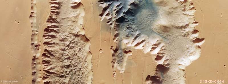
Deze afbeelding van ESA's Mars Express toont Ius en Tithonium Chasmata, die deel uitmaken van de Valles Marineris-canyonstructuur van Mars. Deze afbeelding bestaat uit gegevens die op 21 april 2022 zijn verzameld door de High Resolution Stereo Camera (HRSC) van Mars Express. De afbeelding is gemaakt met behulp van gegevens van het nadirkanaal, het gezichtsveld dat loodrecht op het oppervlak van Mars is uitgelijnd en de kleurkanalen van de HRSC . Het is een 'echte kleuren'-afbeelding, die weerspiegelt wat het menselijk oog zou zien als we naar dit gebied van Mars zouden kijken. De grondresolutie is ongeveer 25 m/pixel en het beeld is gecentreerd op ongeveer 272°E/6°S. Het noorden is aan de rechterkant. Krediet:ESA/DLR/FU Berlijn, CC BY-SA 3.0 IGO
De nieuwste afbeelding van ESA's Mars Express neemt ons mee over twee breuken in de korst van Mars die deel uitmaken van het machtige Valles Marineris-canyonsysteem.
Valles Marineris snijdt door Mars zoals de Grand Canyon door de Verenigde Staten loopt, behalve dat de laatste in vergelijking minuscuul is. Met een lengte van 4000 km, een breedte van 200 km en een diepte tot 7 km is Valles Marineris bijna tien keer langer, 20 keer breder en vijf keer dieper dan de Grand Canyon. Als het grootste canyonsysteem in het zonnestelsel zou het de afstand van de noordpunt van Noorwegen tot de zuidpunt van Sicilië overspannen.
Er is nog een groot verschil tussen de twee:terwijl de Grand Canyon werd gevormd toen de Colorado-rivier de rotsen erodeerde, wordt aangenomen dat Valles Marineris is ontstaan door het uiteendrijven van tektonische platen.
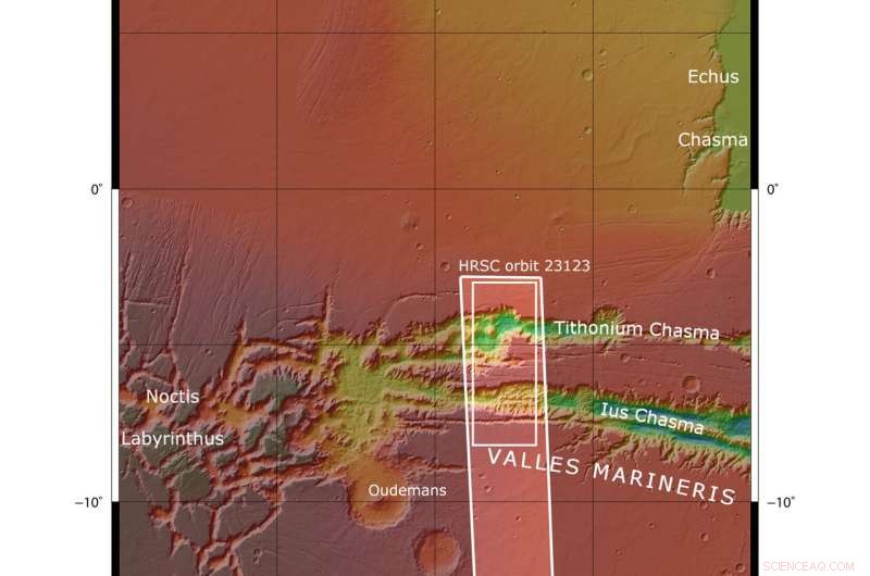
De afbeelding toont twee loopgraven (of chasma) die deel uitmaken van de westelijke Valles Marineris. Links (zuiden) ligt de 840 km lange Ius Chasma en rechts (noorden) de 805 km lange Tithonium Chasma. Hoewel deze afbeeldingen met hoge resolutie ongelooflijke oppervlaktedetails laten zien, realiseren we ons pas als we naar een hoogtekaart kijken hoe spectaculair diep de chasmata zijn - tot 7 km! Met 4809 m zou de hoogste berg van de Alpen, de Mont Blanc, in het niet vallen als hij in Tithonium Chasma zou worden geplaatst.

Deze afbeelding van ESA's Mars Express toont Ius en Tithonium Chasmata, die deel uitmaken van de Valles Marineris-canyonstructuur van Mars. Het gebied dat wordt omlijnd door het vetgedrukte witte vak geeft het gebied aan dat is afgebeeld door de Mars Express High Resolution Stereo Camera op 21 april 2022 tijdens een baan om 23123. Credit:NASA/MGS/MOLA Science Team
Op de top van Tithonium Chasma zorgt een stukje donker zand voor een kleurcontrast in het beeld. Dit zand is mogelijk afkomstig uit het nabijgelegen vulkanische gebied Tharsis.
Naast de donkere zandduinen zijn twee lichtgekleurde heuvels (een doormidden gesneden door de bovenste afbeeldingsrand). Deze "heuvels" lijken meer op bergen, die meer dan 3000 meter hoog zijn. Their surfaces have been strongly eroded by Mars' strong winds, indicating that they are made of a weaker material than the surrounding rock.
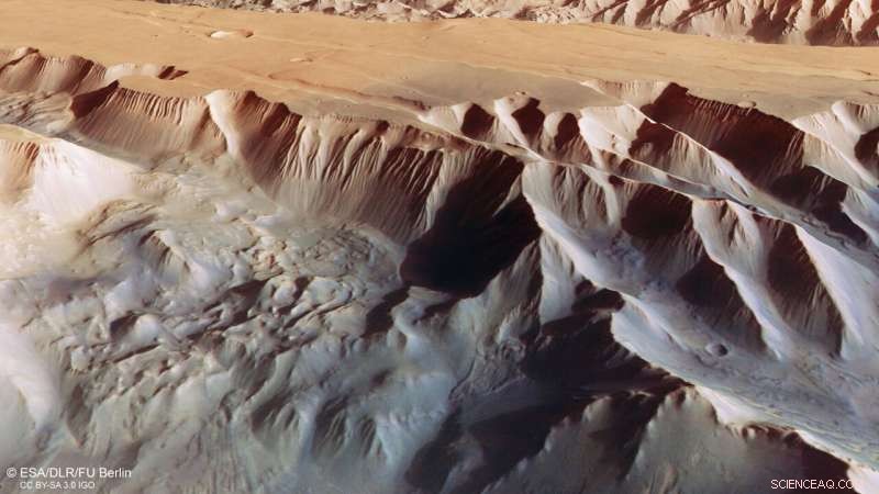
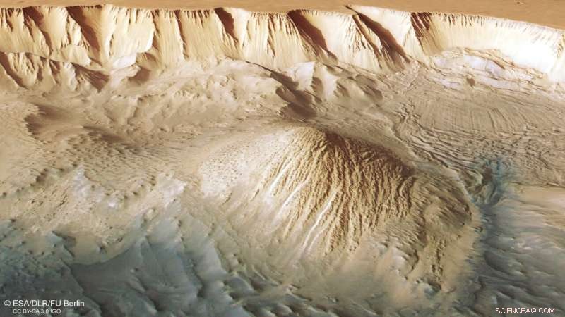
Between the two mounds we see a series of smaller bumps, as shown in the second perspective view. Investigations by Mars Express have found water-bearing sulfate minerals in this region. This suggests that these bumps may have formed when liquid that once filled the chasma evaporated, although this theory is still hotly debated.
-

This oblique perspective view of Tithonium Chasmata, which forms part of Mars’ Valles Marineris canyon structure, was generated from the digital terrain model and the nadir and colour channels of the High Resolution Stereo Camera on ESA’s Mars Express. Credit:ESA/DLR/FU Berlin, CC BY-SA 3.0 IGO
-

This oblique perspective view of Tithonium Chasmata, which forms part of Mars’ Valles Marineris canyon structure, was generated from the digital terrain model and the nadir and colour channels of the High Resolution Stereo Camera on ESA’s Mars Express. Credit:ESA/DLR/FU Berlin, CC BY-SA 3.0 IGO
To the lower right of the mound that we see fully (upper right in the second perspective view), we can see parallel lines and debris piles that indicate a recent landslide. This is also visible as a large purple area in the topography image below. The landslide was caused by the collapse of the canyon wall on the right, and is likely to have occurred relatively recently because it has not been strongly eroded.
The gnarly floor of Ius Chasma is equally fascinating. As tectonic plates pulled apart, they appear to have caused jagged triangles of rock to form that look like a row of shark teeth. Over time, these rock formations have collapsed and eroded.
Exploring Mars
Mars Express has been orbiting the Red Planet since 2003, imaging Mars' surface, mapping its minerals, identifying the composition and circulation of its tenuous atmosphere, probing beneath its crust, and exploring how various phenomena interact in the Martian environment.
The mission's High Resolution Stereo Camera (HRSC), responsible for these new images, has revealed much about Mars' diverse surface features, with recent images showing everything from wind-sculpted ridges and grooves through impact craters and channels that once carried liquid water to volcanoes, tectonic faults, river channels and ancient lava pools. + Verder verkennen
Image:Layers and fractures in Ophir Chasma, Mars
 Ontwikkeling van kern-schaal functionele composieten met uitstekende zelfsmerende eigenschappen
 Enzym kan een sleutelrol spelen bij het ontwerpen van medicijnen voor borstkanker en hersenaandoeningen
 Nieuwe bevindingen werpen licht op de ontwikkeling van op liposomen gebaseerde remmers
 Waarom heeft ijs een lagere warmtecapaciteit dan vloeibaar water?
  Hoe krijg ik gekleurde lichtere vlammen
 Klimaat om de theeproductie in Kenia te verwoesten
 Onderzoeker onderzoekt de rol van non-profitorganisaties bij het herstel van de gemeenschap van de olieramp in Deepwater Horizon
 Waar is de winter? West-Europa koestert zich in recordtemperaturen
 Gevaarlijke stoffen in gezonken vrachtschip voor de kust van Frankrijk:autoriteiten
 Ozonaantasting verhoogt Antarctische sneeuwval, vermindert gedeeltelijk het verlies van ijskappen
Hoofdlijnen
- Golgi-apparaat: functie, structuur (met analogie en diagram)
- Codominantie: definitie, toelichting en voorbeeld
- Wat is een gen?
- Hoe beïnvloeden je hersenen je overlevingskansen in de wildernis?
- 3 fasen van interfase
- Waarom je moet letten op vliegend braaksel
- Is het waar dat als je drie weken iets doet, het een gewoonte wordt?
- Onderzoekers ontdekken dat het nauwkeurig transcriberen van DNA het herstel van DNA opheft
- Welk percentage botten in het lichaam bestaat uit het axiale skelet?
 Wat telt voor ons klimaat:CO2-budgetten ontward
 Dramatische toename van microplastics in zeegrasbodem sinds de jaren 70
 Calcium-oxalaat
 Nieuwe techniek werkt als versneller, rem voor microscopisch kleine druppels
 Kenmerken van een Flood Plain
  Officieel:Chinese maansonde zal Frans vervoeren, Russische uitrusting
 Wat is kwantumgekte?
  Het verschil tussen een ringvormige en een totale zonsverduistering
- Elektronica
- Biologie
- Zonsverduistering
- Wiskunde
- French | Italian | Spanish | Portuguese | Swedish | German | Dutch | Danish | Norway |

-
Wetenschap © https://nl.scienceaq.com


