Wetenschap
Kunnen windturbines en trekvogels naast elkaar bestaan?
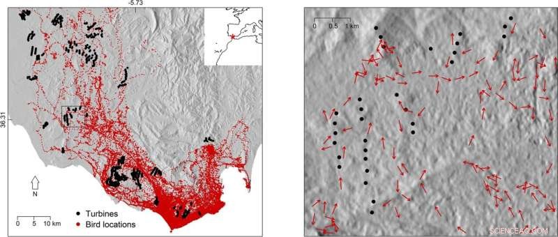
Linkerpaneel toont de ruimtelijke verdeling van vogel- en turbinelocaties in het studiegebied tussen Cadiz en Tarifa (Zuid-Spanje). Rode asterisk in de inzet rechtsboven markeert de locatie van het studiegebied. Het rechterpaneel toont de vluchtrichtingen van vogels in vergelijking met turbinelocaties in een klein deel van het studiegebied (vierkant in het linkerpaneel). Heuvelschaduw werd toegevoegd als achtergrond om de interactie tussen het ruimtegebruik van vogels en topografie te illustreren. De gegevens die werden gebruikt om heuvelschaduw te illustreren, zijn opgehaald uit een openbaar beschikbaar digitaal hoogtemodel (https://lpdaac.usgs.gov). Krediet:Wetenschappelijke rapporten (2022). DOI:10.1038/s41598-022-10295-9
In de race om een op hol geslagen klimaatverandering te voorkomen, worden twee technologieën voor hernieuwbare energie gepromoot als de oplossing voor het voeden van menselijke samenlevingen:wind en zonne-energie. Maar al vele jaren liggen windturbines op ramkoers met natuurbehoud. Vogels en andere vliegende dieren riskeren de dood door impact met de rotorbladen van turbines, wat vragen oproept over de haalbaarheid van wind als hoeksteen van een wereldwijd beleid voor schone energie. Nu hebben een paar diervolgstudies van het Max Planck Institute of Animal Behaviour en de University of East Anglia, VK, gedetailleerde GPS-gegevens opgeleverd over het vlieggedrag van vogels die vatbaar zijn voor botsingen met energie-infrastructuur. De eerste, een grootschalige studie van 1454 vogels van 27 soorten, heeft hotspots in Europa geïdentificeerd waar vogels een bijzonder risico lopen door windturbines en hoogspanningslijnen. De tweede zoomde in op hoe vogels zich gedragen wanneer ze in de buurt van turbines vliegen, en onthulde dat individuen turbines actief zullen vermijden als ze zich binnen een kilometer bevinden. Door de beweging van vogels te volgen met zeer nauwkeurige GPS-apparaten, leveren beide onderzoeken de gedetailleerde biologische gegevens die nodig zijn om de infrastructuur voor hernieuwbare energie uit te breiden met minimale gevolgen voor dieren in het wild.
De opwekking van windenergie is de afgelopen twee decennia toegenomen met de wereldwijde inzet om over te stappen op hernieuwbare energie uit koolstof-emitterende fossiele brandstoffen. De Europese capaciteit voor windenergie op land zal naar verwachting tegen 2050 bijna verviervoudigen, en landen in het Midden-Oosten en Noord-Afrika, zoals Marokko en Tunesië, hebben ook doelstellingen om het aandeel van de elektriciteitsvoorziening uit wind op land te vergroten.
"We know from previous research that there are many more suitable locations to build wind turbines than we need in order to meet our clean energy targets up to 2050," said lead author Jethro Gauld, a Ph.D. researcher in the School of Environmental Sciences at University of East Anglia. "If we can do a better job of assessing risks to biodiversity, such as collision risk for birds, into the planning process at an early stage we can help limit the impact of these developments on wildlife while still achieving our climate targets."
Pinpointing collision hotspots in Europe
An international team of 51 researchers from 15 countries, including the Max Planck Institute of Animal Behavior in Germany, collaborated to identify the areas where these birds would be more sensitive to onshore wind turbine or power line development. The study, published in Journal of Applied Ecology , used GPS location data from 65 bird tracking studies to understand where they fly more frequently at danger height—defined as 10 to 60 meters above ground for power lines and 15 to 135 meters for wind turbines. "GPS tracking provides very accurate data on location and flight height, which cannot be obtained from direct observation, particularly from large distances," says Martin Wikelski, director at the Max Planck Institute of Animal Behavior and co-author on the study. "This study represents the first time GPS data from so many species has been pooled to create a comprehensive picture of where birds are at risk.
The resulting vulnerability maps reveal that the collision hotspots are particularly concentrated within important migration routes, along coastlines and near breeding locations. These include the Western Mediterranean coast of France, Southern Spain and the Moroccan Coast—such as around the Strait of Gibraltar—Eastern Romania, the Sinai Peninsula and the Baltic coast of Germany. The GPS data collected related to 1,454 birds from 27 species, mostly large soaring ones such as white storks. Exposure to risk varied across the species, with the Eurasian spoonbill, European eagle owl, whooper swan, Iberian imperial eagle and white stork among those flying consistently at heights where they risk collision. The authors say development of new wind turbines and transmission power lines should be minimized in these high sensitivity areas, and any developments which do occur will likely need to be accompanied by measures to reduce the risk to birds.
How birds behave near turbines
As well as providing location and flight height, GPS loggers open up an additional frontier in efforts to better plan energy infrastructure. "With GPS tracking we are able to understand exactly how birds behave as they fly close to the turbines," says Carlos Santos, an Affiliated Scientist of the Max Planck Institute of Animal Behavior and an Assistant Professor at the Federal University of Pará, in Brazil. "Knowing how close they fly, and whether or not wind or other factors influence their flight behavior, is very important to mitigate collision rates as it can help better planning of wind farms."
A team of scientists from the Max Planck Institute of Animal Behavior and the University of East Anglia focused their attention on the black kite, a very common soaring bird that migrates through the Strait of Gibraltar, the narrow straight between southern Spain and North Africa. "The Strait of Gibraltar is the main migratory bottleneck for birds in western Europe but it's also a hotspot for wind farms," says Santos. "We wanted to see how soaring birds behave in this area, which represent a serious threat during their migration to Africa."
This study, published in Scientific Reports , looked at GPS information from 126 black kites as the birds approached wind turbines. The data showed that birds avoided flight paths straight to turbines as they flew closer to them. The birds started to deviate from turbines one kilometer away, but this effect was even more pronounced within 750 meters and when the wind was blowing towards the turbines. "This means that they recognize the risk of the turbines and keep a safe distance from them," says Santos.
The authors say collecting GPS data from the interaction between birds and turbines is extremely difficult. Says Santos:"You need to tag many animals to increase the chances of recording their behavior near the turbines. This is why our dataset is so uncommon. Fortunately, GPS tracking studies are becoming more common and hopefully in the near future we will be able to gather data of this sort for other soaring bird species." The authors stress that understanding how the birds perceive wind turbines and which factors attenuate or exacerbate their perception is critical to learn where to place turbines and to develop effective deterrents.
 Oudste Amerikanen waren het meest gericht op het verminderen van voedselverspilling
- Virus treft grootste Arctische expeditie in de geschiedenis
- Waarschuwingsstatus vulkanen Bali verlaagd na verminderde activiteit
- Los Angeles bespaart water op recordniveaus, maar het is niet genoeg als de droogte verergert
- VN-chef zegt dat wereld niet op schema ligt met klimaatverandering
Hoofdlijnen
- Onderzoekers voeren een nieuwe analyse van het tarwemicrobioom uit onder vier managementstrategieën
- Nachtvliegers of dagjesmensen? Studie werpt licht op wanneer motten, vlinders zijn actief
- Chinese fossiele eieren tonen achteruitgang van dinosauriërs voordat ze uitstierven
- Vermont ziet hedendaags record voor reproductie van Amerikaanse zeearenden
- Verschil tussen gekoppelde en vrijstaande ribosomen
- Mysteriegen rijpt het skelet van de cel
- Wat is nodig voor de glycolyse om te beginnen?
- Nieuw model bevestigt dat bedreigde rechtse walvissen afnemen
- Hoe beïnvloeden allelen inherente eigenschappen?
- Van Zuidoost-Azië tot de riolen:studie bepaalt nieuwe geografische oorsprong van bruine ratten
- Nieuwe methode om sneller en nauwkeuriger antigenen te vinden die specifieke immuuncellen activeren

- Tekenen kunnen helpen, kunnen geschiedenisliefhebbers helpen om meer buff te krijgen
- Chimerisme:je kunt je eigen tweeling zijn

- Zelfvernietiging van muggen

 Klimaatrapport zegt dat 2016 op schema ligt om het warmste jaar tot nu toe te worden
- Nieuwe landelijke kaart van luchtvervuiling geeft inzicht in stikstofdioxidegehalte
- Met nieuwe techniek kunnen onderzoekers de spanning in zonnecellen van de volgende generatie in kaart brengen
- Een beetje vriendelijkheid is goed voor de prestaties en gezondheid van werknemers
- Wat zijn echte diamanten?
- Tanzaniaanse boeren stimuleren diëten, geestelijke gezondheid met duurzame methoden
- Vuurvliegjes werpen licht op de functie van mitochondriën
- Australische bosbranden geblust, maar klimaatruzies woeden voort
- Elektronica
- Biologie
- Zonsverduistering
- Wiskunde
- French | Italian | Spanish | Portuguese | Swedish | German | Dutch | Danish | Norway |

-
Wetenschap © https://nl.scienceaq.com
